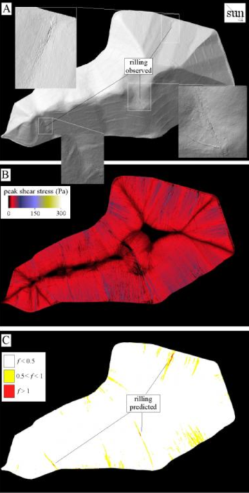
RILLGEN2D predictions for a mine waste site in Arizona studied for a ten-year period, with comparison to where rilling has been observed.
Mining companies can more cost effectively deal with slope erosion on legacy—or closed—sites using a new modeling technique developed by a University of Arizona geosciences professor.
Jon Pelletier is recruiting companies to become part of a cooperative that will focus on reducing costs to mitigate soil erosion with smarter planning of slope location and design.
Pelletier’s RILLGEN2D numerical model helps designers and engineers truly understand how water is eroding slopes by identifying where waterways run through the structure. These waterways will eat up slope foundations, causing rills within the structure that have to be repaired to keep tailings from running off. If not handled correctly, this condition can trigger a regulatory penalty.
“If you allow erosion to proceed unchecked, you have a significant perpetual maintenance cost,” Pelletier said. “In some sense, it’s an infinite cost. Companies really want to design closure that is monitored over time, but they don’t want to have to do intervention.”
Additionally, the environmental imperative of Pelletier’s work on erosion mitigation is clear. “After mining operations cease, it is critical to stabilize the mine waste piles and guarantee that they will be resilient to dust and water erosion that could impact neighboring ecosystems or population centers,” said CESM Director Julie Neilson. “Jon is developing a model that will improve the technology to stabilize waste slopes and minimize closed-site management expenses.”
Flowing down and sideways: model tracks slope water in two directions
Pelletier uses photographic satellite and LIDAR, or laser-driven, images to map out the landscape under slopes or for future slope structures. Pelletier is looking for gullies and other slight depressions. That’s important because these features become waterways in rainfall, especially the sudden deluges from arid and semi-arid monsoonal conditions.
Pelletier runs the images through a numerical model. RILLGEN2D “predicts the erosional stability of reclamation designs,” he said, “including the two-dimensional convergence of water flow that is a major driver of erosion at the tailing embankment.”
Instead of merely determining how water flows down slopes, his work also takes into account where in the slope will water flow and pool from waterways. Currently, almost all of the numerical models that are used for predicting erosion on reclaimed mine sites examine only water flow down embankment slopes.
Pelletier has used his modeling process for two years on a reclaimed mine in south-central Arizona. He has helped a mining consulting firm deal with persistent erosion of the slopes that were created during the open pit copper ore operation, which closed in 1999. “They wanted to do a postmortem on what went on,” he said. “They’re trying to plan for closure throughout the life cycle of a mine.”
“The best companies think about closure from the very beginning.”
Consortiums include industry to apply research broadly
Image
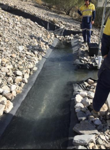
Testing of the water flow properties of a detention basin at the base of a plot designed to measure water and sediment discharge.
With preliminary results of this project in hand, Pelletier is ready to expand development of RILLGEN2D using the CESM model of building consortiums, or cooperatives, to further the science and apply it to mining environmental and sustainability issues.
Currently there is a consortium focused on revegetation technology for mine waste. It combines UArizona researchers and experts from the environmental sciences department and the School of Natural Resources and the Environment with mining companies that provide sites for research. Specific recommendations are given to consortium members and results are shared with the general public. The group also provides real-world educational opportunities for students.
Working like this consortium, the new research initiative can further refine this water-erosion modeling technique. “The advantage is you can apply your research question on multiple mine sites with multiple conditions,” Neilson said. “If you can bring multiple companies to the table, you can have a broader field of sites that you can apply your research to.”
Pelletier said that his modeling technique can help a company understand the implications of their slope design when it’s time for the mine to move toward closure. But that attention also applies to far earlier efforts to build tailings slopes. “The best companies,” he said, “think about closure from the very beginning.”